
Iran Travel Booking > About Iran > World Heritage Site in Iran > Maymand
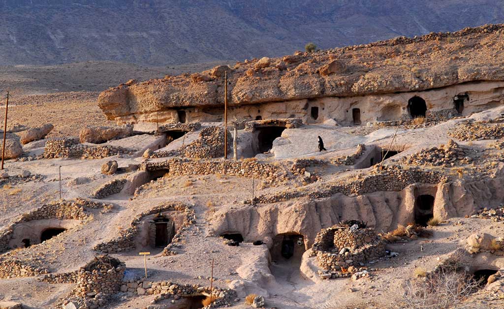
Maymand is a self-contained, semi-arid area at the end of a valley at the southern extremity of Iran’s central mountains. The villagers are semi-nomadic agro-pastoralists. They raise their animals on mountain pastures, living in temporary settlements in spring and autumn. During the winter months they live lower down the valley in cave dwellings carved out of the soft rock (kamar), an unusual form of housing in a dry, desert environment. This cultural landscape is an example of a system that appears to have been more widespread in the past and involves the movement of people rather than animals.
Outstanding Universal Value
Brief Synthesis
Maymand is a small and relatively self-contained south facing valley within the arid chain of Iran’s central mountains. The villagers are agro-pastoralists who practice a highly specific three phase regional variation of transhumance that reflects the dry desert environment. During the year, farmers move with their animals to defined settlements, traditionally four, and more recently three, that include fortified cave dwellings for the winter months. In three of these settlements the houses are temporary, while in the fourth, the troglodytic houses are permanent.
Sar-e-Āghol are the settlements on the southern fields used from the end of winter until late spring. The houses come in two different types. Markhāneh are circular houses, semi-underground to shelter them from the wind, with low dry stone wall and a roof covering of wood and thatch of wild thistles. Mashkdān houses are above ground and built with dry stone walls and a conical roof of branches. Some of the buildings for cattle are much more substantial and have barrel vaulted brick or stone roofs.
Sar-e-Bāgh houses are sited near seasonal rivers and used during summer and early autumn. When the weather is hot the structures are light: dry stone walls support a roof structure of vertical and horizontal timbers covered with grass thatch. In inclement weather more substantial houses are constructed with taller stone walls and a conical roof. Cattle are collected in roofless stone enclosures. Around these summer villages are the remains of terraces for growing wheat and barley, and the remains of mostly now ruined water-mills. Pits for boiling and straining grape juice are still in use as are Kel-e-Dūshāb which are used to contain the resulting Dūshāb or syrup of grapes.
The winter troglodytic houses are carved out of the soft rock, in layers of up to five houses in height. Around 400 Kiches or houses have been identified and 123 units are intact. Each house has between one and seven rooms, traditionally used for living, and storage.
In the exceptionally arid climate, traditionally every drop of water needed to be collected from a variety of sources such as rivers, springs and subterranean pools and collected in reservoirs or channelled through underground qanats to be used for animals, orchards and small vegetable plots. The community has a strong bond with the natural environment that is expressed in social practices, cultural ceremonies and religious beliefs.
Criterion (v): The Cultural Landscape of Maymand, a small mainly self-sufficient community within one large valley, reflects a traditional three phase transhumance system with unusual troglodytic winter housing in a dry desert environment. It is a good example of a system that appears to have been once more widespread, and involves the movement of people rather than animals to three defined settlement areas, one of which is cave dwellings.
Integrity
All the components of the landscape reflecting the agro-pastoral system and permanent and seasonal dwellings are within the boundaries. The components are however vulnerable, in relation to the resilience of the transhumance systems. This continues for the present, with a decreasing population. Although the small irrigated fields survive in outline they no longer are used to grow staple crops for self-sufficient families. Improved communications, such as with nearby towns means that people can look after their animals and vegetable plots in different ways than previously. As a result far fewer people are over-wintering in the troglodytic villages than a generation ago and there are far fewer families using the seasonal settlements. Only around 90 out of 400 of the troglodytic dwellings are inhabited during the winter. A few more of them are inhabited only during weekends, when people return from the nearest town to where they have moved. The number of Āghols has reduced in the last few years due to the decreasing numbers of pastoralists. In the property there remain at least 8 Āghols that are still living and used by families who have sufficient cattle to ensure their survival. There are two others that are abandoned. Most of the seasonal buildings are largely re-constructed each season and are therefore a reflection of a traditional practice that has persisted for generations. But this is a practice that is highly vulnerable and could disappear within a generation, if the pastoral way of life is not attractive or sufficiently viable for the younger generation.
Authenticity
There is little doubt of the authenticity of most of the components of the property, in terms of the landscape itself and the traditional practices that interact with it, as reflected in troglodytic houses, seasonal shelters and water structures. Some of the latter have been adapted in recent decades and only two of the qanats survive. The troglodytic structures have undergone extensive restoration over the past ten years.
Authenticity is also vulnerable to a weakening of traditional practices which could lead to a reduction in the size of the community that manages the landscape, to more families only living in the valley during the summer months, and to the impacts of tourism in particular on the troglodytic dwellings.
Protection and management requirements
The troglodyte village is registered in the National Heritage List, and is protected under the Historical Monument’s Protection and Conservation Law. It is understood that the whole property will be legally protected upon inscription in line with other inscribed properties in Iran.
The property is also protected by other cultural and natural Iranian laws, such as the Iranian Civil Law that forbids transferring the ownership of public monuments and prohibits private ownership of significant cultural property. The Islamic Penal Law also protects the property, as no restoration, repair, renovation, transfer, or change of functions, etc. of registered monuments can be done without the Iranian Cultural Heritage, Handicrafts and Tourism Organization approval. The area is also under regulation concerning natural heritage protecting the natural environment.
Since 2001 the Iranian Cultural Heritage, Handicrafts and Tourism Organization has assumed responsibility for the property and a Maymand Cultural Heritage Base has been established, with close links to the Maymand village council and the Maymand village administration office. The local council manages the day-to-day affairs in collaboration with the Maymand Cultural Heritage Base. There are currently adequate local resources for administration
A Management Plan in the initial nomination set out regulations for the property area. For the buffer zone, large scale plans that may include industrial complexes and development projects such as highways, etc. must be agreed by the Iranian Cultural Heritage and Tourism Organisation.
Details of an augmented plan, arising from a workshop that aimed to encourage sustainable development for the local communities by opening up engagement between them and national and regional agencies, have been provided. This will focus on raising awareness of the legacy that the communities sustain, and put in place a sustainable development framework based on support and encouragement for innovative ways to add value to local produce, as well as some official support such as for dredging qanats and vaccinating livestock. This sustainable development plan has only recently been framed and clearly more work will be needed to translate it into an action plan with an agreed timescale and necessary resources.
Three other plans have also been developed by University Departments. These are: Evaluation of Ecological Capabilities, Agro-Pastoral lifestyle description and comparative study, and Research project on the impact of Water Sources and Farming. In addition a local team is engaged in mapping the activities of the farming year.
In spite of these initiatives and the engagement of the local community in a dialogue on how to sustain the dynamic landscape practices, there is nevertheless still concern that such a small community of some 70 families can form a sustainable and resilient unit that will keep the Maymand agro-pastoral system alive, even if in the future it does not survive in neighbouring valleys. Authenticity and integrity are thus vulnerable to a weakening of traditional practices.
Sustainable development will undoubtedly need to harness appropriate tourism opportunities. A plan is needed to set out how tourism might be managed in such a way that it supports rather than detracts from local traditions and avoids turning the village into a museum and contributing to the demise of agro-pastoral traditions.
Information source: http://whc.unesco.org/


